Research on Birdoswald Roman Fort
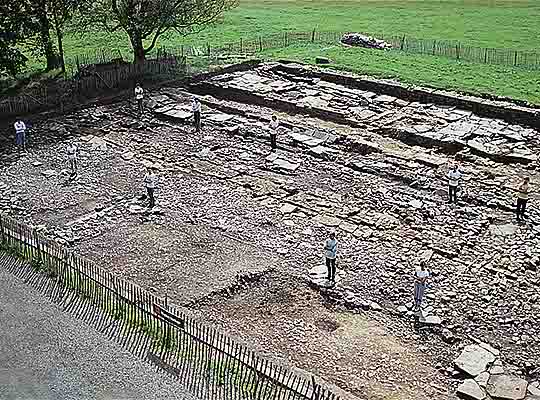
Over a century of excavation has revealed the structural history of the fort from construction in the 2nd century to desertion in the 6th century, and its use from medieval to modern times. The fort, its vicus (civilian settlement) and cemetery have all been partially excavated. In addition, the extent of the vicus has been revealed through geophysics.

Excavations in the 19th Century
Work undertaken from 1832 to 1852 by two proprietors of the site, Thomas Crawhall (who also made the first examination of turret 49b)[1] and Henry Norman, together with the Potter brothers, revealed the fort walls and gates. This was done both to enhance the landscape and in a spirit of enquiry. The Potters published their work quickly, with accurate engravings by John Storey.[2] Henry Norman, in laying out his garden in front of the house, made the first excavation of the granaries.[3]
Francis Haverfield, excavating with the Cumberland Excavation Committee between 1895 and 1898, established clearly that the turf Wall was earlier than the fort and that the Vallum was diverted to the south of the fort.
Excavations in the 20th and 21st Centuries
In 1911, FG Simpson began work at Birdoswald, examining the stone Wall turrets west of Birdoswald, including turret 49b.[4] Between the wars, in a great campaign of excavations along Hadrian’s Wall designed to establish the relationship of the various elements of stone and turf Walls, the forts and the Vallum, FG Simpson focused much of his attention on Birdoswald.
Together with Ian Richmond, Simpson conducted seven consecutive seasons of work beginning in 1927, first under the Durham University Excavation Committee and after 1930 under the Cumberland Excavation Committee. The following areas were examined:
- 1927: the east fort rampart and the turf Wall under the fort
- 1928: the south-west corner of the fort, the fort ditches and the relationship between fort and Vallum
- 1929: a barrack block on the east side of the fort. This excavation identified four dated levels, which had huge influence on the formulation of the four Wall periods that were the basis of Wall research for 50 years
- 1930–31: the east and south defences; rapid trenching established an outline building plan
- 1932–3: the Vallum, ditches and timber structures south of the fort.
Turf Wall turret 49a was discovered under the fort in 1945. From 1949 to 1952 consolidation of the fort walls and gates took place, and archaeological recording was undertaken by JP Gillam.[5] In 1959–60 a cremation cemetery to the west of the fort was discovered during ploughing.
Excavations resumed in 1987, directed by Tony Wilmott for English Heritage. Areas examined were:
- 1987–91: the former gardens in front of the farmhouse, revealing the granaries, exercise or drill hall, workshops and main west gate. These excavations identified the post-Roman structures and the medieval and post-medieval sequence
- 1988–9: the north wall and interval towers
- 1992: the minor east gate and wall, and the south-east angle tower
- 1997–8: the area of the visitor centre, identifying barrack blocks beneath the buildings and courtyards
- 1999,[6] 2009: the cemetery to the west of the site.
Geophysical Survey
Extensive geophysical survey was conducted in the 1990s, revealing for the first time the extent of the settlement around the fort, including to the north of the Wall.[7]
Gaps in Current Knowledge
The recent work has given us a very good understanding of the fort interior and of the area to the south of the fort, as well as some appreciation of the history of the cemetery. In particular, the post-Roman phases are now well understood.
There is one yawning gap in our understanding, however, and that is in the extramural settlement around the fort. Specific questions to be asked here are:
- when was the vicus initiated, and when did it come to an end?
- what activities took place there?
- who lived there?
- what is the plan and nature of the vicus through time, and in particular what form did occupation north of the Wall take?
READ MORE ABOUT BIRDOSWALD ROMAN FORT
Footnotes
1. J Hodgson, History of Northumberland, part II, vol 1 (Newcastle upon Tyne, 1840), 207.
2. HG Potter, ‘Amboglanna: communicated to the Society of Antiquaries of Newcastle-upon-Tyne, Nov. 6, 1850’, Archaeologia Aeliana, 1st series, 4 (1855), 63–9; HG Potter, ‘Amboglanna: communicated to the Society of Antiquaries of Newcastle-upon-Tyne, Nov. 5, 1851’, Archaeologia Aeliana, 1st series, 4 (1855), 69–75; HG Potter, ‘Amboglanna: communicated to the Society of Antiquaries of Newcastle-upon-Tyne, Dec. 1852’, Archaeologia Aeliana, 1st series, 4 (1855), 141–9 (all accessed 31 July 2013).
3. H Norman, ‘An account of recent excavations at Amboglanna (Birdoswald)’, Archaeologia Aeliana, 2nd series, 4 (1860), 249 (accessed 31 July 2013).
4. FG Simpson, ‘Excavations on the line of the Roman Wall in Cumberland during the years 1909–1912’, Transactions of the Cumberland and Westmorland Antiquarian and Archaeological Society, new series, 13 (1913), 297–397.
5. JP Gillam, ‘Recent excavations at Birdoswald’, Transactions of the Cumberland and Westmorland Antiquarian and Archaeological Society, new series, 50 (1950), 63–8.
6. Time Team excavation project, designed by Tony Wilmott (accessed 22 February 2018).
7. JA Biggins and DJA Taylor, ‘A survey of the Roman fort and settlement at Birdoswald, Cumbria’, Britannia, 30 (1999), 91–110 (subscription required; accessed 31 July 2013); JA Biggins and DJA Taylor, ‘Geophysical survey of the vicus at Birdoswald Roman Fort, Cumbria’, Britannia, 35 (2004), 159–77 (subscription required; accessed 31 July 2013).