Description of Harrows Scar Milecastle and Wall
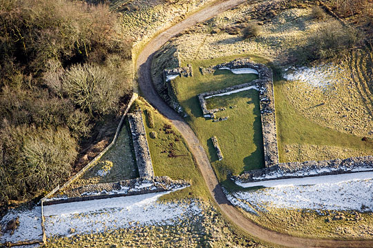
Nothing can now be seen of the turf Wall and milecastle that preceded the stone structures in the stretch of Hadrian’s Wall between Birdoswald Roman Fort and Harrows Scar Milecastle. The length of stone Wall itself, however, is one of the highest surviving, with a number of inscriptions and phallic symbols remaining in position. The basic plan of the stone milecastle is clear, as are traces of later buildings within it.

Milecastle
Milecastles were small guard posts built at intervals of one Roman mile along the Wall, usually with two gates to allow access through it. Milecastle 49 at Harrows Scar lies on the edge of the western cliff of the river Irthing, overlooking the Roman bridge that carried the Wall across the river at Willowford.
The outer walls of the milecastle mostly survive to a height of two or three courses (continuous horizontal layers of stone). The plan – a rectangular fortlet attached to the Wall, but with rounded southern corners – is clear, as are the sites of the two large gates to north and south. The south-east corner has been lost to river erosion. A farm track crosses the milecastle from the south-east corner, exiting on the site of the north gate.
The milecastle walls are some 2.3 metres wide, as is the stone replacement of the turf Wall which they abut.
The wall footings within the milecastle relate to the post-medieval building recorded in 1603.[1]
Hadrian’s Wall
From Harrows Scar Milecastle to Birdoswald Fort, the Wall is 2.3 metres wide and survives to a height of up to ten courses (2 metres). This is one of the longest high-standing stretches to survive.
The Wall was built at the base of a slope from the south, and drainage was thus important. Regular drains can be seen in its base at intervals of 6 metres and towards Birdoswald a later drain was inserted. This now appears, strangely, to be above ground level, but it would have been inserted at a time when a build-up of soil, washed downslope, would have compromised the proper functioning of the original drains.
Symbols and Inscriptions
This part of the Wall is made unusually interesting by the presence of carved phallic symbols and of several ‘centurial’ stones, which feature the names of centurions in charge of the work parties who built the Wall.
The positions of these are marked by small metal strips mortared into the wall footings a course above the present ground level. They are listed below by their distance from the west wall of the milecastle:
- 64 metres: ‘century of Marcus Rufus’ (almost illegible)
- 68 metres: ‘century of Carus Scipio’
- 190 metres: phallic symbol
- 245 metres: ‘century of Julius Primus, cohort VIII’ (the clearest example)
- 254 metres: ‘century of Secundinus Verullus built 30 paces’
- 275 metres: ‘century of the Primus Pilus’ (>PP)
- 349 metres: ‘century of Tertius’ (see Significance of Harrows Scar)
- 374 metres: phallic symbol (very clearly visible).[2]
A further ten inscribed stones were found in material collapsed from the Wall.
READ MORE ABOUT HARROWS SCAR MILECASTLE AND WALL
Footnotes
1. IA Richmond, ‘Excavations at Milecastle 49 (Harrows Scar)’, Transactions of the Cumberland and Westmorland Antiquarian and Archaeological Society, new series, 56 (1956), 18–27.
2. This list is taken from DJ Breeze, J Collingwood Bruce’s Handbook to the Roman Wall, 14th edn (Newcastle upon Tyne, 2006), 293.