History of Willowford Wall, Turrets and Bridge
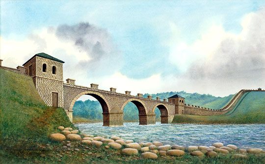
The Willowford sector of Hadrian’s Wall includes the east abutment of a bridge that carried Hadrian’s Wall over the river Irthing, and two turrets (48a and 48b). It also has some of the best-preserved parts of the Wall itself. Both the Wall and the turrets here clearly illustrate the decision made while the Wall was being built to reduce its width. The bridge was remodelled at least twice, being widened to take a road in the late 2nd or early 3rd century AD.

Initial Building
Building began in about AD 122 with the laying of the first three or four courses of a wall 10 Roman feet (3 metres) wide (the Broad Wall). Before the Wall could be completed to this plan, its width was reduced to 8 Roman feet (2.2 metres) (the Narrow Wall).[1] Work on the bridge over the river Irthing and the two turrets (48a and 48b) seems to have been carried much further before the change in the specification for the Wall, though it is impossible to say whether they were finished in the first stage of overall construction.[2]
The original bridge, like that at Chesters, had stone arches, but was only wide enough to carry the Wall, which had a walkway along the top, across the river. At the east end there was access to the bridge from ground level by means of a tower, partly recessed into the Wall. This was presumably matched by another at the western end.
The Bridge Rebuilt
An attempt was made to protect the east end of the bridge and the tower by revetting the river bank, but eventually a catastrophic flood swept away the abutment and the easternmost river pier.[3] When the bridge was rebuilt, it still served only to take the Wall across the river. The fallen arch was replaced by a timber span,[4] and the original tower by another, of larger size, further east.
These events took place before the end of the 2nd century but cannot be dated more closely.
Turrets
Both turrets contained four superimposed floors of clay or flagstones, but no pottery was recovered from either dating from later than the beginning of the 3rd century.[5] At this period many other turrets along the Wall, especially those in the central sector, were demolished, their walls being reduced to ground level. However, turret 48a and perhaps turret 48b, though no longer occupied, seem to have remained standing.
The Bridge Widened
In the late 2nd or early 3rd century the bridge was rebuilt to take a road across the Irthing.[6] A ramp was built behind the Wall to take the Military Way, a service road added to the existing installations on the Wall, up to the level of the carriageway across the river.
The east abutment of the rebuilt bridge took a very different form from that at Chesters. A thin wall of stone blocks revetted the river bank and the first river pier was a rectangular foundation separated from the abutment by a narrow channel.[7] The form of the remainder of the bridge is unknown, but it is likely to have been a far less elaborate structure than the Chesters road bridge. This is probably because unlike the latter it only took the Military Way across the river rather than the Stanegate (which usually ran behind the Wall) as well. The Stanegate ran south of the Irthing for a further 8 miles to the west, eventually crossing it near Castlesteads.
All that is known of the subsequent history of the bridge is that stone blocks were removed from it for reuse in 4th-century repairs to the east wall of the fort at Birdoswald.[8]
Post-Roman History
Remains of the bridge were seen by the antiquary William Camden on his northern tour in 1599.[9] At that time the course of the Irthing was further to the east than it is now, and the bases of the bridge piers might have been visible in the river bed.
In the 1830s some of the bridge remains were dismantled to provide stone for the building of Willowford farm.[10] Later in the 19th century, JC Bruce noted that part of the east bridge abutment was visible and that there were indications of the site of turret 48b.[11]
The abutment was given to the nation by Lord and Lady Henley in 1939. Between 1950 and 1964, the Wall from the Gilsland road to the bridge was dug out and consolidated. The manner in which this was done caused great controversy, following complaints by the archaeologist and writer, Jacquetta Hawkes, and was the subject of a debate in the House of Commons in 1958.
READ MORE ABOUT WILLOWFORD WALL, TURRETS AND BRIDGE
About the Author
Paul Bidwell is Head of TWM Archaeology, a section of Tyne and Wear Archives and Museums. He has published extensively on Hadrian’s Wall, Roman south-west England, Roman architecture and Roman ceramics.
Footnotes
1. FG Simpson, Watermills and Military Works on Hadrian’s Wall, ed G Simpson (Kendal, 1976), 64–7.
2. PR Hill, The Construction of Hadrian’s Wall, BAR British Series 375 (Oxford, 2004), 144–51.
3. P Bidwell and N Holbrook, Hadrian’s Wall Bridges, English Heritage Archaeological Report 9 (London, 1989), 76–7.
4. Ibid, 79–83.
5. RC Shaw, ‘Excavations at Willowford’, Transactions of the Cumberland and Westmorland Antiquarian and Archaeological Society, 2nd series, 26 (1926), 445–50.
6. Bidwell and Holbrook, op cit, 95–6.
7. Ibid, 91–4.
8. T Wilmott, Birdoswald: Excavations of a Roman Fort on Hadrian’s Wall and Its Successor Settlements, English Heritage Archaeological Report 14 (London, 1997), 183–7.
9. W Camden, Britannia, trans. P Holland (London, 1637), 785.
10. HI Jenkinson, Jenkinson’s Practical Guide to Carlisle, Gilsland, Roman Wall and Neighbourhood (London, 1875), 199.
11. JC Bruce, Handbook to the Roman Wall, 3rd edn (London and Newcastle upon Tyne, 1885), 195 (accessed 1 Nov 2012).