Romans

ROMAN COASTAL DEFENCES AND THE SAXON SHORE

A reconstruction drawing of the west wall of the Roman fort at Pevensey as it may have looked in about AD 300

A reconstruction drawing of the west wall of the Roman fort at Pevensey as it may have looked in about AD 300. © Historic England (illustration by Peter Urmston)

A reconstruction drawing of the west wall of the Roman fort at Pevensey as it may have looked in about AD 300. © Historic England (illustration by Peter Urmston)

In the 3rd century AD, several Roman forts were built along the Channel coasts of east and south-east England and northern Gaul. All were built at strategically important coastal estuaries and inlets, and most of them survive in some form today.

They are known as the ‘forts of the Saxon Shore’ from a single reference in a much later Roman document, the Notitia Dignitatum, which describes them as being under the control of a Count of the Saxon Shore. This has led to a long-standing assumption that the forts were built to house Roman soldiers fighting off piratical ‘Saxon’ raiders. Today, the name is enshrined in a 153-mile long-distance footpath, the Saxon Shore Way.

But what do we really know about the coast, its defences and its assailants in the later years of Roman Britain? We explore the evidence for where, when and why these forts were built.

WHERE ARE THE FORTS?

A reconstruction of the west side of the Saxon Shore fort at Richborough, Kent

A reconstruction drawing of the west gate and wall of the Saxon Shore fort at Richborough, Kent, as they may have looked in the early 4th century AD. © English Heritage Trust (illustration by Simon Edwards)

A reconstruction drawing of the west gate and wall of the Saxon Shore fort at Richborough, Kent, as they may have looked in the early 4th century AD. © English Heritage Trust (illustration by Simon Edwards)

Nine forts listed in the Notitia as being under the Count of the Saxon Shore’s command have been identified with Roman remains on the east and south-east coasts of England, between the Wash in northern Norfolk and the Solent in Hampshire. They are:

Brancaster (Branodunum), Norfolk

The outline of the fort at Brancaster is dramatically revealed in this aerial photograph by parching of the grass over its buried ramparts, revealing the positions of gates, traces of internal buildings and, at the top of the image, an external settlement

The outline of the fort at Brancaster is dramatically revealed in this aerial photograph by parching of the grass over its buried ramparts, revealing the positions of gates, traces of internal buildings and, at the top of the image, an external settlement. © Norfolk Historic Environment Service (photo by Derek Edwards)

The outline of the fort at Brancaster is dramatically revealed in this aerial photograph by parching of the grass over its buried ramparts, revealing the positions of gates, traces of internal buildings and, at the top of the image, an external settlement. © Norfolk Historic Environment Service (photo by Derek Edwards)

The fort at Brancaster was built to guard the approaches to the Wash. It covered 2.6 hectares, was rectangular with rounded corners (the ‘playing card’ shape typical of early Roman forts in Britain) and had walls 2.7 metres thick. Its remains are now almost entirely under the ground.

Burgh Castle (Gariannonum), Norfolk

The impressive wall and south-west corner tower of the Roman fort at Burgh Castle

The impressive wall and south-west corner tower of the Roman fort at Burgh Castle, still standing close to their original height

The impressive wall and south-west corner tower of the Roman fort at Burgh Castle, still standing close to their original height

The remains at Burgh Castle, on a low hill above the river Waveney, are now some distance inland. In Roman times the fort was on the shore of a large sheltered inlet. It enclosed 2.4 hectares, and its walls remain on three sides, 3.5 metres thick and in places still 4.5 metres high. There are six projecting towers or bastions, possibly added later to the original design.

Bradwell-on-Sea (Othona), Essex

The 7th-century chapel of St Peter-on-the-Wall at Bradwell-on-Sea stands on the site of the Roman fort’s west gate

The 7th-century chapel of St Peter-on-the-Wall at Bradwell-on-Sea stands on the site of the Roman fort’s west gate and incorporates much reused Roman building material. © Tony Watson/Alamy Stock Photo

The 7th-century chapel of St Peter-on-the-Wall at Bradwell-on-Sea stands on the site of the Roman fort’s west gate and incorporates much reused Roman building material. © Tony Watson/Alamy Stock Photo

Othona was located to control the estuaries of the Blackwater and Colne which led to the important Roman city of Camulodonum (Colchester). Sections of three walls formerly survived, one with a bastion, but by the 18th century they had been demolished. Although the site of the fort survives, the eastern wall has never been located.

Reculver (Regulbium), Kent

The impressive towers of the ruined church of St Mary at Reculver lie inside the former Roman fort. The fort’s defensive wall lies along the inside of the road bordering the large green field in the photograph

The impressive towers of the ruined church of St Mary at Reculver lie inside the former Roman fort. The fort’s defensive wall lies along the inside of the road bordering the large green field in the photograph, separating it from the caravan park

The impressive towers of the ruined church of St Mary at Reculver lie inside the former Roman fort. The fort’s defensive wall lies along the inside of the road bordering the large green field in the photograph, separating it from the caravan park

Reculver guarded the northern end of a lost seaway (the Wantsum Channel) that divided the Isle of Thanet from the mainland. Substantial remains of the fort walls survive, although about half the site has been lost to the sea. The fort was nearly square, with rounded corners, and measured 180 metres by 175 metres.

Richborough (Rutupiae), Kent

The north wall of the Roman fort at Richborough

The north wall of the Roman fort at Richborough. The remarkable coursed facing stones testify to the skill of the masons employed on its construction

The north wall of the Roman fort at Richborough. The remarkable coursed facing stones testify to the skill of the masons employed on its construction

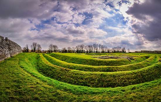
Richborough is probably the place where the Roman invasion force landed in AD 43, at the southern end of the Wantsum Channel. It developed from a military base into a port town before successive forts were added to the site during the 3rd century. The triple ditches of the first fort of about AD 250 survive, while the impressive stone walls of a fort built about AD 275–85 are the most prominent feature of the site today.

Dover (Dubris), Kent

Seventy years after the invasion in AD 43, the Romans began to build a fort at Dover at the mouth of the river Dour for the classis Britannica, a Roman fleet based in the English Channel. This was abandoned around AD 225 and a new fort was built about AD 270. Its site has been built over, but parts have been excavated.

Lympne (Portus Lemanis), Kent

Aerial photograph showing the remains of the fort wall at Lympne

This aerial photograph shows the remains of the fort wall at Lympne. The unstable surface geology of the site has resulted in landslips that have broken and moved huge chunks of the wall, so that its original form is no longer obvious

This aerial photograph shows the remains of the fort wall at Lympne. The unstable surface geology of the site has resulted in landslips that have broken and moved huge chunks of the wall, so that its original form is no longer obvious

On Romney Marsh, and now well inland from the coast, this fort was built in the shape of an irregular pentagon of about 3.4 hectares. Several sections of wall survive, up to 6 metres tall, but mostly leaning and displaced by land slips.

Pevensey (Anderida), East Sussex

The west gate of the Roman fort at Pevensey, showing its two huge D-shaped flanking towers

The west gate of the Roman fort at Pevensey, showing its two huge D-shaped flanking towers

The west gate of the Roman fort at Pevensey, showing its two huge D-shaped flanking towers

Pevensey’s walls form an irregular oval shape, enclosing 4 hectares. Its projecting D-shaped towers are a new feature of Roman fortification, appearing in the late 3rd century. The walls were used later to define the outer bailey of a medieval castle.

Portchester (Portus Adurni), Hampshire

The walls and projecting towers of the Roman fort at Portchester are remarkably complete

A view south to Portsmouth Harbour across the walls of the Roman fort at Portchester. Its multiple towers project from the wall on the right of the image, although the prominent gate there is largely a medieval rebuilding

A view south to Portsmouth Harbour across the walls of the Roman fort at Portchester. Its multiple towers project from the wall on the right of the image, although the prominent gate there is largely a medieval rebuilding

Portchester has the best-preserved Roman fort walls north of the Alps. They form a regular square enclosure which is complete for most of the circuit, except where they were interrupted or altered in the 12th century by the medieval castle built in one corner. The Roman fort originally had 20 projecting D-shaped bastions, of which 14 survive.

As well as the nine forts listed in the Notitia, there are two other Roman fort sites on the east coast:

Caister Roman Site, Norfolk

Aerial view of the remains of a building inside the fort at Caister

The remains of a building inside the fort at Caister on Sea, possibly the house of its commanding officer. The fort wall runs across the top of the photograph, with the foundations of a square tower of the south gate towards the top left

The remains of a building inside the fort at Caister on Sea, possibly the house of its commanding officer. The fort wall runs across the top of the photograph, with the foundations of a square tower of the south gate towards the top left

The estuary over which Caister once presided has greatly silted up and much of the fort is now covered by modern housing. Sections of the outer wall and ditch of the fort survive, however, as well as the remains of some internal buildings. The fort of nearly 3.5 hectares was roughly square.

Walton Castle, Suffolk

A copy of a drawing dated 1623 of Walton Castle, Suffolk

The wall of the fort at Walton Castle, on an 18th-century copy of a drawing originally made in 1623. The similarity to Burgh Castle is clear. © The Picture Art Collection/Alamy Stock Photo

The wall of the fort at Walton Castle, on an 18th-century copy of a drawing originally made in 1623. The similarity to Burgh Castle is clear. © The Picture Art Collection/Alamy Stock Photo

The fort at Walton Castle has sometimes been identified with Portus Adurni, although that is more usually identified with Portchester. It was destroyed by coastal erosion in the 18th century.

The Notitia also lists two more places across the Channel, in the Roman provinces of Germania Inferior and Gallia Belgica, as being on the Saxon Shore. These are at Oudenburg (in what is now Belgium) and Aardenburg (Netherlands).

A map of the forts of the Saxon Shore
A map of the Saxon Shore forts

Nine forts listed in the Notitia as being under the Count of the Saxon Shore’s command have been identified with Roman remains on the east and south-east coasts of England, between the Wash in northern Norfolk and the Solent in Hampshire. They are:

Brancaster (Branodunum), Norfolk

The outline of the fort at Brancaster is dramatically revealed in this aerial photograph by parching of the grass over its buried ramparts, revealing the positions of gates, traces of internal buildings and, at the top of the image, an external settlement

The outline of the fort at Brancaster is dramatically revealed in this aerial photograph by parching of the grass over its buried ramparts, revealing the positions of gates, traces of internal buildings and, at the top of the image, an external settlement. © Norfolk Historic Environment Service (photo by Derek Edwards)

The outline of the fort at Brancaster is dramatically revealed in this aerial photograph by parching of the grass over its buried ramparts, revealing the positions of gates, traces of internal buildings and, at the top of the image, an external settlement. © Norfolk Historic Environment Service (photo by Derek Edwards)

The fort at Brancaster was built to guard the approaches to the Wash. It covered 2.6 hectares, was rectangular with rounded corners (the ‘playing card’ shape typical of early Roman forts in Britain) and had walls 2.7 metres thick. Its remains are now almost entirely under the ground.

Burgh Castle (Gariannonum), Norfolk

The impressive wall and south-west corner tower of the Roman fort at Burgh Castle

The impressive wall and south-west corner tower of the Roman fort at Burgh Castle, still standing close to their original height

The impressive wall and south-west corner tower of the Roman fort at Burgh Castle, still standing close to their original height

The remains at Burgh Castle, on a low hill above the river Waveney, are now some distance inland. In Roman times the fort was on the shore of a large sheltered inlet. It enclosed 2.4 hectares, and its walls remain on three sides, 3.5 metres thick and in places still 4.5 metres high. There are six projecting towers or bastions, possibly added later to the original design.

Bradwell-on-Sea (Othona), Essex

The 7th-century chapel of St Peter-on-the-Wall at Bradwell-on-Sea stands on the site of the Roman fort’s west gate

The 7th-century chapel of St Peter-on-the-Wall at Bradwell-on-Sea stands on the site of the Roman fort’s west gate and incorporates much reused Roman building material. © Tony Watson/Alamy Stock Photo

The 7th-century chapel of St Peter-on-the-Wall at Bradwell-on-Sea stands on the site of the Roman fort’s west gate and incorporates much reused Roman building material. © Tony Watson/Alamy Stock Photo

Othona was located to control the estuaries of the Blackwater and Colne which led to the important Roman city of Camulodonum (Colchester). Sections of three walls formerly survived, one with a bastion, but by the 18th century they had been demolished. Although the site of the fort survives, the eastern wall has never been located.

Reculver (Regulbium), Kent

The impressive towers of the ruined church of St Mary at Reculver lie inside the former Roman fort. The fort’s defensive wall lies along the inside of the road bordering the large green field in the photograph

The impressive towers of the ruined church of St Mary at Reculver lie inside the former Roman fort. The fort’s defensive wall lies along the inside of the road bordering the large green field in the photograph, separating it from the caravan park

The impressive towers of the ruined church of St Mary at Reculver lie inside the former Roman fort. The fort’s defensive wall lies along the inside of the road bordering the large green field in the photograph, separating it from the caravan park

Reculver guarded the northern end of a lost seaway (the Wantsum Channel) that divided the Isle of Thanet from the mainland. Substantial remains of the fort walls survive, although about half the site has been lost to the sea. The fort was nearly square, with rounded corners, and measured 180 metres by 175 metres.

Richborough (Rutupiae), Kent

The north wall of the Roman fort at Richborough

The north wall of the Roman fort at Richborough. The remarkable coursed facing stones testify to the skill of the masons employed on its construction

The north wall of the Roman fort at Richborough. The remarkable coursed facing stones testify to the skill of the masons employed on its construction

Richborough is probably the place where the Roman invasion force landed in AD 43, at the southern end of the Wantsum Channel. It developed from a military base into a port town before successive forts were added to the site during the 3rd century. The triple ditches of the first fort of about AD 250 survive, while the impressive stone walls of a fort built about AD 275–85 are the most prominent feature of the site today.

Dover (Dubris), Kent

Seventy years after the invasion in AD 43, the Romans began to build a fort at Dover at the mouth of the river Dour for the classis Britannica, a Roman fleet based in the English Channel. This was abandoned around AD 225 and a new fort was built about AD 270. Its site has been built over, but parts have been excavated.

Lympne (Portus Lemanis), Kent

Aerial photograph showing the remains of the fort wall at Lympne

This aerial photograph shows the remains of the fort wall at Lympne. The unstable surface geology of the site has resulted in landslips that have broken and moved huge chunks of the wall, so that its original form is no longer obvious

This aerial photograph shows the remains of the fort wall at Lympne. The unstable surface geology of the site has resulted in landslips that have broken and moved huge chunks of the wall, so that its original form is no longer obvious

On Romney Marsh, and now well inland from the coast, this fort was built in the shape of an irregular pentagon of about 3.4 hectares. Several sections of wall survive, up to 6 metres tall, but mostly leaning and displaced by land slips.

Pevensey (Anderida), East Sussex

The west gate of the Roman fort at Pevensey, showing its two huge D-shaped flanking towers

The west gate of the Roman fort at Pevensey, showing its two huge D-shaped flanking towers

The west gate of the Roman fort at Pevensey, showing its two huge D-shaped flanking towers

Pevensey’s walls form an irregular oval shape, enclosing 4 hectares. Its projecting D-shaped towers are a new feature of Roman fortification, appearing in the late 3rd century. The walls were used later to define the outer bailey of a medieval castle.

Portchester (Portus Adurni), Hampshire

The walls and projecting towers of the Roman fort at Portchester are remarkably complete

A view south to Portsmouth Harbour across the walls of the Roman fort at Portchester. Its multiple towers project from the wall on the right of the image, although the prominent gate there is largely a medieval rebuilding

A view south to Portsmouth Harbour across the walls of the Roman fort at Portchester. Its multiple towers project from the wall on the right of the image, although the prominent gate there is largely a medieval rebuilding

Portchester has the best-preserved Roman fort walls north of the Alps. They form a regular square enclosure which is complete for most of the circuit, except where they were interrupted or altered in the 12th century by the medieval castle built in one corner. The Roman fort originally had 20 projecting D-shaped bastions, of which 14 survive.

As well as the nine forts listed in the Notitia, there are two other Roman fort sites on the east coast:

Caister Roman Site, Norfolk

Aerial view of the remains of a building inside the fort at Caister

The remains of a building inside the fort at Caister on Sea, possibly the house of its commanding officer. The fort wall runs across the top of the photograph, with the foundations of a square tower of the south gate towards the top left

The remains of a building inside the fort at Caister on Sea, possibly the house of its commanding officer. The fort wall runs across the top of the photograph, with the foundations of a square tower of the south gate towards the top left

The estuary over which Caister once presided has greatly silted up and much of the fort is now covered by modern housing. Sections of the outer wall and ditch of the fort survive, however, as well as the remains of some internal buildings. The fort of nearly 3.5 hectares was roughly square.

Walton Castle, Suffolk

A copy of a drawing dated 1623 of Walton Castle, Suffolk

The wall of the fort at Walton Castle, on an 18th-century copy of a drawing originally made in 1623. The similarity to Burgh Castle is clear. © The Picture Art Collection/Alamy Stock Photo

The wall of the fort at Walton Castle, on an 18th-century copy of a drawing originally made in 1623. The similarity to Burgh Castle is clear. © The Picture Art Collection/Alamy Stock Photo

The fort at Walton Castle has sometimes been identified with Portus Adurni, although that is more usually identified with Portchester. It was destroyed by coastal erosion in the 18th century.

The Notitia also lists two more places across the Channel, in the Roman provinces of Germania Inferior and Gallia Belgica, as being on the Saxon Shore. These are at Oudenburg (in what is now Belgium) and Aardenburg (Netherlands).

The page from the Notitia Dignitatum showing the command of the Count of the Saxon Shore

A page from a medieval copy of the Notitia Dignitatum, dated 1436, showing the places under the command of the Count of the Saxon Shore. © Bodleian Libraries, University of Oxford (MS Canon Misc. 378 f 153v)

A page from a medieval copy of the Notitia Dignitatum, dated 1436, showing the places under the command of the Count of the Saxon Shore. © Bodleian Libraries, University of Oxford (MS Canon Misc. 378 f 153v)

The Notitia Dignitatum

The Notitia Dignitatum (or ‘List of Offices’) is an official document that lists the senior military and civilian posts throughout the Roman Empire, and their areas of responsibility. It has two distinct parts, covering the eastern and western empires. The part dealing with the eastern empire accurately represents those posts in about AD 395.

A page from a medieval copy of the Notitia Dignitatum, dated 1436, showing the places under the command of the Count of the Saxon Shore. © Bodleian Libraries, University of Oxford (MS Canon Misc. 378 f 153v)

However, the part that covers the western empire, including Britain, seems to be a compilation of several documents of different dates: some of them may have been out of date when they were assembled into one, and some sections are missing. It was probably compiled between AD 390 and AD 420, though some of the information may be much older.

The Notitia gives the title of a very senior officer, Comes litoris Saxonici per Britanniam, ‘the Count of the Saxon Shore in Britain’, together with a list of the places and garrison units under his command. But we don’t know how long the Count’s command had existed when the Notitia was compiled.

We also don’t know why the Notitia uses the name ‘Saxon Shore’. However, it is most likely to derive from an area of the North Sea and Channel coasts which was plagued by ‘Saxon raiders’, crossing in ships from their homelands beyond the Roman imperial frontiers. To Roman writers, the term ‘Saxon’ seems to have been a catch-all for several Germanic tribes – including Franks and Frisians – who lived in what are now the northern part of the Netherlands (north of the Rhine estuary), Denmark and northern Germany.

Less probable is that the ‘Saxon Shore’ referred to coastal areas where Saxons had been allowed to settle by the Roman authorities.

WHEN AND WHY WERE THE FORTS BUILT?

Reculver Roman Fort, with sun and shadow picking out its east and south walls

The Roman fort at Reculver, with sun and shadow picking out its east and south walls. This image shows clearly how half of its rectangular form has been lost to the sea

The Roman fort at Reculver, with sun and shadow picking out its east and south walls. This image shows clearly how half of its rectangular form has been lost to the sea

The early 3rd-century forts

In the AD 230s, three forts were built on the east coast of Britain, at Brancaster and Caister-on-Sea (both in Norfolk) and Reculver (Kent). At around the same time, two earlier forts across the Channel, at Oudenburg and Aardenburg, were rebuilt. Oudenburg and Aardenburg had probably initially been built to repel coastal raids by Germanic tribes, which are recorded by Roman writers from the later 2nd century AD. Archaeology has revealed evidence for the building of forts along this coast at the time.

A reconstruction of an inscription found in the headquarters building at Reculver, recording its construction, possibly in the AD 230s

A reconstruction of an inscription found in the headquarters building at Reculver, recording its construction, possibly in the AD 230s. It mentions a man named Rufinus, possibly Q. Aradius Rufinus, who held high office in Africa in AD 238

A reconstruction of an inscription found in the headquarters building at Reculver, recording its construction, possibly in the AD 230s. It mentions a man named Rufinus, possibly Q. Aradius Rufinus, who held high office in Africa in AD 238

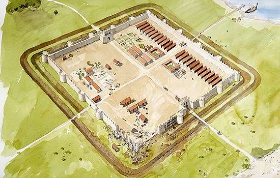
Brancaster, Caister and Reculver all have similar ‘playing card’ plans – rectangular, with rounded corners – with perimeter defences of stone walls backed by broad internal earth ramparts. They are broadly similar to Roman fort plans in Britain in the 1st and 2nd centuries AD. Two gateways excavated at Reculver had single portals, one revealed at Caister had a double portal, while Brancaster’s may also have been double.

A reconstruction drawing of the south gate at Caister in the 3rd century AD, showing its double gateway

A reconstruction drawing of the south gate at Caister in the 3rd century AD, showing its double gateway, a familiar feature of Roman forts in Britain in the first two centuries AD. © Historic England (illustration by Sue White)

A reconstruction drawing of the south gate at Caister in the 3rd century AD, showing its double gateway, a familiar feature of Roman forts in Britain in the first two centuries AD. © Historic England (illustration by Sue White)

The internal buildings at Reculver resemble those of many earlier Roman forts, including a headquarters, barracks and the commanding officer’s quarters, while the only structure explored at Caister is part of a courtyard building, perhaps originally the commanding officer’s house but later partially used as a workshop. Brancaster’s interior departs from standard planning, with one building on a different alignment from the street grid; this may have been a mansio – a guest house and posting station for the imperial postal service. This fort also contains an arena for training cavalry horses, a rare find in Britain.

Some historians have seen these newly built forts and the rebuilt forts across the Channel as part of the first cross-Channel system of defence against coastal raiders. But there is no documentary evidence for raiding in Britain at this time, and though two of the forts appear in the Notitia, they were built at least 160 years before its compilation.

The later forts

The later 3rd century saw more forts built along the east and south-east coasts of Britain, of which substantial remains survive. They are at Burgh Castle (Norfolk), Bradwell-on-Sea (Essex), Richborough, Dover and Lympne (Kent), Pevensey (East Sussex) and Portchester (Hampshire). Together with the earlier 3rd-century forts, they make up the full list of the forts mentioned in the Notitia. One more – not mentioned in the Notitia but of similar design, with thick, tall stone walls and projecting towers or bastions – was formerly called Walton Castle but is now entirely lost to the sea.

These later forts in Britain are of very different design from the earlier Brancaster, Caister and Reculver. They lack a uniform shape and the standard layouts of earlier forts, probably revealing a major change in military organisation and strategy. They vary in shape from the elongated rectangle of Burgh Castle and the impressive square of Portchester to the irregular polygon of Lympne and the elongated oval of Pevensey.

This aerial view shows the regular shape of the Roman fort at Burgh Castle, lacking only its west wall, which long ago collapsed. Its remains are now buried in marshland

The regular shape of the Roman fort at Burgh Castle lacks only its west wall, which collapsed long ago. Its remains are now buried in marshland

The regular shape of the Roman fort at Burgh Castle lacks only its west wall, which collapsed long ago. Its remains are now buried in marshland

The curving Roman walls of the fort at Pevensey, with its projecting towers, later used as the outer defences of a medieval castle

The curving Roman walls of the fort at Pevensey, with its projecting towers, later used as the outer defences of a medieval castle, which is visible in the background

The curving Roman walls of the fort at Pevensey, with its projecting towers, later used as the outer defences of a medieval castle, which is visible in the background

Most of them have massive stone walls up to 4 metres wide and up to 8 metres high. Usually these are without an earth rampart backing them, though Dover and Bradwell did have earth ramparts.

A new feature in British forts is the systematic use of massive projecting towers, both rectangular and round, spaced along the walls and at the fort corners. These enabled soldiers to send defensive fire along the walls. The forts have fewer gates than earlier forts, and these generally have single portals. At Portchester and Pevensey, the gates are massively defended, and recessed from the wall line to create confined killing areas overlooked on three sides.

A reconstruction drawing of the Roman west gate at Portchester. The gatehouse is recessed into the fort defences to create an area that could be defended from three locations on the battlements

A reconstruction drawing of the Roman west gate at Portchester. The gatehouse is recessed into the fort defences to create an area that could be defended from three locations on the battlements. © Historic England (illustration by Terry Ball)

A reconstruction drawing of the Roman west gate at Portchester. The gatehouse is recessed into the fort defences to create an area that could be defended from three locations on the battlements. © Historic England (illustration by Terry Ball)

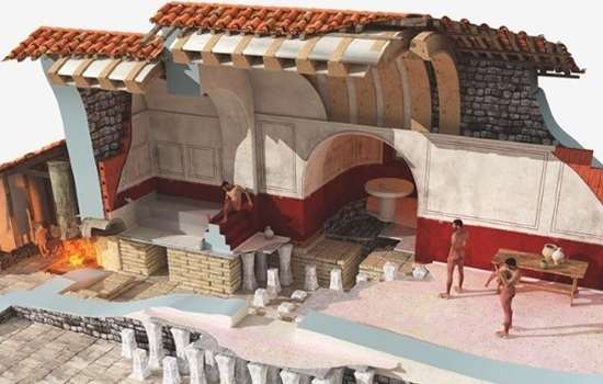
We know little about the internal arrangements of these forts, despite some extensive excavations. Most buildings were probably of wood, as only a few permanent stone buildings have been revealed, including bath-houses at Dover and Richborough. It is clear at Portchester, however, that women and children lived inside the fort, alongside men serving in the army.

Archaeologists have shown that these forts were built at various times between about AD 260 and AD 300, while Portchester and Pevensey can be more closely dated to around AD 286 and AD 293 respectively.

Some of the forts may have been on the site of earlier structures, notably the one at Dover, where a fort that had existed from around AD 130 had been abandoned around AD 225. At Richborough, a small triple-ditched fort had been established in about AD 250, before a large stone fort superseded it sometime between AD 275 and AD 290.

The mid-3rd-century fortlet at Richborough which was superseded by the larger Saxon Shore fort

The mid-3rd-century fortlet at Richborough. It was built around an earlier monumental arch, and superseded by a much larger fort about 30 years later. © Historic England/English Heritage Trust (illustration by Simon Edwards)

The mid-3rd-century fortlet at Richborough. It was built around an earlier monumental arch, and superseded by a much larger fort about 30 years later. © Historic England/English Heritage Trust (illustration by Simon Edwards)

Why might these later forts have been built?

Roman writers record that by the mid 3rd century AD Germanic raiders were regularly attacking the Channel coast on the continental side. Although the raiding seems to have been mainly on a small scale, large-scale invasions penetrated well into Gaul in AD 260 and AD 268. There is evidence of fort building along the coast, from the Netherlands across Belgium and northern France, including rebuilding again at Oudenburg and Aardenburg. Although Roman writers make no mention of raids on Britain, it is possible that the British forts were a response to similar invasion threats.

A gold coin of the usurper Carausius (r. AD 286–93), showing him crowned as emperor

A gold coin of the usurper Carausius (r. AD 286–93), showing him crowned as emperor. © Trustees of the British Museum

A gold coin of the usurper Carausius (r. AD 286–93), showing him crowned as emperor. © Trustees of the British Museum

Another possibility, however, is that the forts may not have been built to defend the Roman Empire at all. From AD 260, Britain was part of two breakaway mini-empires, both of which involved open conflict with the main Roman Empire. The first was the Gallic Empire, initiated by Postumus (ruled AD 260–69), a military commander. The emperor Aurelian restored rule from Rome in AD 274, but in AD 286 Carausius, the commander of the Roman Channel fleet, proclaimed himself emperor in Britain and northern Gaul. His breakaway empire survived until his successor, Allectus, was defeated in AD 296.

It could have been Postumus who was responsible for coastal fort building on the continent, and perhaps also for the later coastal forts in Britain. However, archaeological dating of the British forts suggests that Carausius or Allectus are more likely to have built them.

In short, the forts may have been built originally to defend Britain against Rome, rather than against Germanic raiders.

A reconstruction drawing of Reculver Roman Fort as it may have appeared in about AD 250, showing a regular layout of buildings typical in forts of the previous 200 years

A reconstruction drawing of Reculver Roman Fort as it may have appeared in about AD 250, showing a regular layout of buildings typical in forts of the previous 200 years. © Historic England (illustration by Peter Urmston)

A reconstruction drawing of Reculver Roman Fort as it may have appeared in about AD 250, showing a regular layout of buildings typical in forts of the previous 200 years. © Historic England (illustration by Peter Urmston)

A remarkable D-shaped tower on the south wall of Portchester fort. Next to it lies the medieval Watergate, and two more Roman towers beyond that

A remarkable D-shaped tower on the south wall of Portchester fort. Next to it lies the medieval Watergate, and two more Roman towers beyond that

A remarkable D-shaped tower on the south wall of Portchester fort. Next to it lies the medieval Watergate, and two more Roman towers beyond that

An aerial view of Richborough

An aerial view of Richborough. On the right are the ditches and surviving outer walls of the square fort built towards the end of the 3rd century AD. The triple ditches of an earlier fortlet can be seen inside their circuit (left)

An aerial view of Richborough. On the right are the ditches and surviving outer walls of the square fort built towards the end of the 3rd century AD. The triple ditches of an earlier fortlet can be seen inside their circuit (left)

THE FORTS IN THE 4TH CENTURY

The west wall of the Roman fort at Pevensey, which survives almost to its full height of about 8 metres

The west wall of the fort at Pevensey survives almost to its full height of about 8 metres, and retains its projecting towers

The west wall of the fort at Pevensey survives almost to its full height of about 8 metres, and retains its projecting towers

The era of rival Roman emperors and civil war that affected Britain from AD 260 ended in AD 324 when Constantine I (r. AD 306–37) became sole Roman emperor. He had regained control of all the north-western provinces of the empire by AD 312. The reconstruction of the fort at Oudenburg in AD 325–30, with wall towers like those in the later group of British forts, may have been part of Constantine’s consolidation of the Channel defences, and perhaps even the origin of the command of the Count of the Saxon Shore.

A marble portrait head of the emperor Constantine I

A marble portrait head of the emperor Constantine I (r.AD 306–37). It may have been Constantine who created the Saxon Shore command. © Metropolitan Museum of Art, New York (Bequest of Mary Clark Thompson, 1923)

A marble portrait head of the emperor Constantine I (r.AD 306–37). It may have been Constantine who created the Saxon Shore command. © Metropolitan Museum of Art, New York (Bequest of Mary Clark Thompson, 1923)

In Britain there is much archaeological evidence for activity in the coastal forts of the east and south-east during the 4th century, but it is also clear that some had been abandoned by the AD 380s – notably Burgh Castle, Lympne and Reculver. This confirms how outdated some of the information in the Notitia – supposedly a compilation of AD 390 or after – is. A few of the forts did continue in use into the early 5th century: the best example is at Richborough, where a large quantity of late Roman coinage (as late as AD 402) has been found.

A rare find inside the fort at Richborough is this late Roman font, used for baptisms in a Christian church

A rare find inside the fort at Richborough is this late Roman font, used for baptisms in a Christian church, and firm evidence of activity in the fort at the very end of the Roman period in Britain

A rare find inside the fort at Richborough is this late Roman font, used for baptisms in a Christian church, and firm evidence of activity in the fort at the very end of the Roman period in Britain

The first recorded raids on the British coast date from the 4th century. The contemporary writer Ammianus Marcellinus makes the first mentions of Saxons affecting Britain in the AD 360s, including the ‘Great Conspiracy’ of AD 367. This is interpreted today as a genuine, if overblown, record of large-scale attacks across Roman Britain by raiders from Scotland, Ireland and across the Channel, which were ended by the intervention of Count Theodosius with units of the Roman field army in AD 367–9.

Theodosius entered Britain at Richborough and made London his base. The coastal forts must have played a significant role during his campaign. During the fighting, a senior Roman officer called Nectaridus, styled comes maritimi tractus (count of the maritime region), was killed or captured. It is tempting to see Nectaridus’ title as identical to the Count of the Saxon Shore.

The remaining years of the 4th century and the early 5th century saw regular soldiers removed piecemeal from Britain to defend Rome and provinces closer to it, in AD 383 under Magnus Maximus and perhaps finally under Constantine III in AD 407. The poet Claudian records another military intervention into Britain in AD 396–9 by General Stilicho:

his [Stilicho’s] was the care which ensured Britain should nor fear the spears of the Scott, nor tremble at the Pict, nor watch all along the shore for the arrival of the Saxon with shifting winds …

What garrisons were left in the coastal forts by the early 5th century remains uncertain, despite the lists in the Notitia.

AN EVOLVING SYSTEM

Portchester’s location has hardly changed since Roman times, right next to and looking out over Portsmouth Harbour

Portchester’s location, right next to and looking out over Portsmouth Harbour, has hardly been affected by coastal change since Roman times

Portchester’s location, right next to and looking out over Portsmouth Harbour, has hardly been affected by coastal change since Roman times

The forts on the east and south-east coasts of Britain have much in common. They were all located on low-lying ground, close to sheltered anchorages at major estuaries and inlets. Some seem to have functioned as pairs, such as Reculver and Richborough at opposite ends of an important waterway, and Caister and Burgh Castle on opposite sides of a huge sheltered inlet.

Map showing the locations of the Roman forts at Burgh and Caister

The forts at Burgh Castle and Caister may have formed a pair, or Burgh may have superseded Caister. They guarded the large estuary of several rivers, to prevent raiders from penetrating inland to the heart of Roman Britain

The forts at Burgh Castle and Caister may have formed a pair, or Burgh may have superseded Caister. They guarded the large estuary of several rivers, to prevent raiders from penetrating inland to the heart of Roman Britain

Such locations gave several potential advantages: the ability to provide facilities for warships patrolling the coast, to supervise military supplies and communications into and out of the province, to control and prevent any hostile access to the interior of Britain and its civilian communities via the major navigable rivers, and to protect merchant shipping and trade.

To perform these tasks effectively, and to intercept raids, the garrisons needed to be mobile, a mixture of infantry and cavalry, though the recorded garrisons of the Saxon Shore forts listed in the Notitia are mainly infantry. Again, we come up against the reliability and currency of the Notitia information.

A reconstruction of a Roman soldier’s helmet found at Burgh Castle, Norfolk

A reconstruction of a Roman soldier’s helmet found at Burgh Castle, using the surviving pieces. This type of helmet originated in the eastern borders of the Roman Empire, and was used widely in the 4th and 5th centuries AD

A reconstruction of a Roman soldier’s helmet found at Burgh Castle, using the surviving pieces. This type of helmet originated in the eastern borders of the Roman Empire, and was used widely in the 4th and 5th centuries AD

But it is clear that these forts originated at different times, and probably for various reasons, over some 70 years of the 3rd century. They evolved over a long time and probably fulfilled many different functions. We cannot be sure when they became part of a unified system under one military commander, the Count of the Saxon Shore, as recorded much later in the Notitia.

However, it seems most likely that the command was created in the early 4th century – using forts that included some possibly built during the breakaway reigns of Carausius and Allectus – and perhaps as part of the consolidation of the empire under Constantine I.

Though the true origins of the Saxon Shore remain elusive, we can be sure that at some time a chain of coastal forts became part of a unified and probably larger military command headed by an important officer. His role appears to have been focused on the south and east, but there is archaeological evidence for late Roman military construction in the north and west, guarding frontiers there. Consequently, the forts of the Saxon Shore that have survived until today are the most striking and lasting reminder of the political and military complexities that afflicted later Roman Britain.

Further reading

DJ Breeze et al, Frontiers of the Roman Empire: The Saxon Shore and the Maritime Coast (Oxford, 2022)

G Barker and S Moorhead, Rebel Emperors of Britain: Carausius and Allectus (London, 2023)

J Cotterill, ‘Saxon raiding and the role of the late Roman coastal forts in Britain’, Britannia 24 (1993), 227–39

S Elliott, Roman Britain’s Pirate King: Carausius, Constantius Chlorus and the Fourth Roman Invasion of Britain (Barnsley, 2022)

S Johnson, The Roman Forts of the Saxon Shore (London, 1976)

M Kulikowski, ‘The “Notitia Dignitatum” as a historical source’, Historia: Zeitschrift für Alte Geschichte 49:3 (2000), 358–77

JC Mann, ‘The Notitia Dignitatum – dating and survival’, Britannia 22 (1991), 215–19

A Pearson, The Roman Shore Forts: Coastal Defences of Southern Britain (Stroud, 2002)

A Pearson, ‘Piracy in late Roman Britain: a perspective from the Viking age’, Britannia 37 (2006), 337–53

S Vanhoutte, ‘The late Roman coastal fort of Oudenburg (Belgium)’, in R Collins et al, Roman Military Architecture on the Frontiers: Armies and Their Architecture in Late Antiquity (Oxford, 2015)

READ MORE ABOUT ROMAN BRITAIN

  • EXPLORE ROMAN BRITAIN

    Browse our articles on the Romans to discover the impact and legacy of the Roman era on Britain’s landscape, buildings, life and culture.

  • THE ROMAN INVASION OF BRITAIN

    In AD 43 Emperor Claudius launched his invasion of Britain. Why did the Romans invade, where did they land, and how did their campaign progress?

  • ROMAN BATHING

    Bathing was central to Roman life. Discover what Roman bath-houses can tell us about the culture and people of Roman Britain.

  • GATEWAY TO BRITANNIA: RICHBOROUGH’S ARCH

    The story of Richborough’s monumental arch reveals the great importance of Richborough to the Romans as the gateway to Britannia.