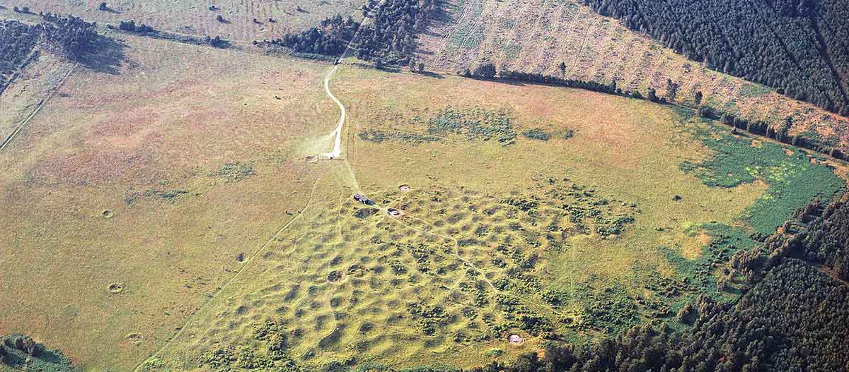
Description of Grime’s Graves
The dips and humps of the earthworks at Grime’s Graves represent the visible remains of 433 mines and pits. Although these earthworks cover an area of nearly 8 hectares, geophysical surveys suggest that originally the mined area may have been much larger.

Topography and Geology
Grime’s Graves lies in an area of undulating heathland, on high ground between the rivers Wissey and Little Ouse. A former water course between these two rivers appears to have shaped the topography to the immediate north of the flint mines, creating a low spur-like promontory where the earthworks now survive.
The geology at Grime’s Graves comprises deposits of chalk which include several seams of flint, all overlain by sandy soils. To the north and east of the mines, a series of parallel chalk ridges support colonies of plants such as rock roses and heath bedstraw.
The shelving chalk geology is deepest in the southern parts of the site, and it forced the Neolithic miners to dig shafts up to 13 metres deep. In the north and west parts, however, only relatively shallow shafts and pits between 3 and 6 metres deep were needed to reach the flint deposits. The deeper mines have subterranean galleries but the shallow pits do not.
The Mines and Pits
Since the 1850s at least 28 mines and pits have been excavated here. The mines were first numbered in 1915 to help record the excavations and allow archaeologists to orientate themselves within the complex site.
Pit 1 (in the north-west part of the site), excavated in 1914,[1] is open to the public. Greenwell's Pit, on the eastern side of the earthworks, was for many years capped with a concrete cover and accessible for research purposes only, but from April 2017 has been reopened for guided tours. Immediately east of Greenwell’s Pit lies the Grimshoe mound. The eroded remains of Pit 2, excavated in 1914–15,[2] lie near the western perimeter of the earthworks.
Most of the earthworks at Grime’s Graves represent single shafts or pits. In the north-east and south-west parts of the site, however, some quarries contain up to nine shafts, suggesting that they may have been excavated in sequence by the same group of miners.
In Pits 1 and 2 and Greenwell’s Pit the base of the pit shaft opens into a series of radiating galleries. Some of the galleries in Pit 1 are more than 15 metres long.
Further Afield
Excavations and recent geophysical surveys[3] suggest that the mines originally covered a much greater area to the west and north – and probably also to the south – which is now hidden by windblown sands and forest.
A possible flint mine found at Buckenham Toft,[4] some 3 miles from Grime’s Graves, suggests that evidence of further local Neolithic mining activity remains to be discovered.
READ MORE ABOUT GRIME’S GRAVES
Footnotes
1. NT Linford, L Martin and J Holmes, Grime's Graves, Norfolk: report on geophysical survey, November 2007, English Heritage Research Report 64/2009 (Swindon, 2009; accessed 1 Sept 2015); information from Dr B Bishop.
2. W Greenwell, 'On the opening of Grime's Graves in Norfolk', Journal of the Ethnological Society of London, new series, 2 (1870), 419–39 (accessed 1 September 2015); M Barber, D Field and P Topping, The Neolithic Flint Mines of England (English Heritage/Royal Commission on the Historical Monuments of England, Swindon, 1999), 75.
3. WG Clarke, Report on the Excavations at Grime's Graves, Weeting, Norfolk, March–May 1914 (London, 1915).
4. Ibid.