History of Benwell Vallum Crossing
Nothing is now visible of the fort at Benwell (Condercum) in Newcastle, which was occupied throughout most of the Roman period by the Asturian cavalry regiment from northern Spain. To the south of the fort site, however, is the only causeway (or permanent crossing) of the Vallum earthwork to be seen on the line of Hadrian’s Wall. The crossing was one of a series of such causeways sited south of the forts, which were the only points where the earthwork known as the Vallum could be crossed to gain access to the zone immediately behind the Wall.

The Vallum
The Vallum was an addition to the original scheme for Hadrian’s Wall, building of which began in about AD 122. Built a short distance behind the Wall, this great earthwork, consisting of a ditch and two banks, ran its full length, except between Newcastle and Wallsend. It probably defined the rear of the military zone.
The Causeway at Benwell
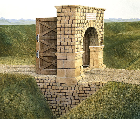
The Vallum causeway at Benwell is at the centre point of a southward deviation of the earthwork around the pre-existing fort. It interrupted the Vallum ditch at a point directly in line with the south gate of the fort (the porta decumana), 55 metres distant from it.
Halfway across the causeway was a gate, which took the form of a free-standing arch supported on massive uprights. This controlled access from the south into the fort and into the zone between the Vallum and the Wall.
Later History
Three layers of road metalling were found on the causeway; the uppermost contained a coin of the AD 270s as well as earlier issues.[1] This latest surface was associated with a block containing a pivot-hole for the spindle of one of the gate leaves (the block has been removed to expose the original pivot-hole). The block had a concave moulding and had been taken from a finely carved cornice, probably from the entablature (the horizontal mouldings above the gateway) of the gate arch.
The reuse of this block shows that the arch, though partly ruinous, was still equipped with wooden gate-leaves in the later 3rd century.
The Vallum ditch on either side of the causeway had been filled by the late 2nd century, and was then covered by buildings of the civilian settlement.[2] Why the gate arch remained is uncertain. Perhaps the line of the abandoned Vallum, still visible in the landscape, continued to represent a boundary between different jurisdictions, and the gate arch marked its course through the civilian settlement.
By Paul Bidwell
READ MORE ABOUT BENWELL VALLUM CROSSING
DOWNLOAD A LOCATION PLAN OF BENWELL ROMAN TEMPLE AND VALLUM CROSSING