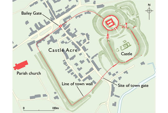
Description of Castle Acre Castle and Bailey Gate
In its final medieval form, the castle consisted of a high motte or mound at the north end, a large outer bailey to the south and a smaller bailey to the east, all defined by earthwork ramparts crowned with stone walls. The motte enclosed and partly buried the remains of an 11th-century domestic building of unique form, much altered in the 12th century. The adjacent town was surrounded by earthwork defences in the mid-12th century, to which stone gatehouses were added in about 1200. The Bailey Gate is the surviving example.

Castle
The castle stands to the east of the town, and formed the town's defences on this side. To the south it borders the river Nar and overlooks the broad valley.
The castle we see today is a fine example of the ‘motte and bailey’ format, but in this case it is the result of successive alterations (see ‘Castle Acre Castle – development of the Inner Bailey’, downloadable from the link below).
Inner Bailey
Covering about 3 hectares (to the outer edges of its defences), the castle has two main parts. At the north end is the circular mound or motte, carrying the inner bailey, and separated from the rising ground to the north-west and from the outer bailey by deep ditches. Remnants survive of the wall encircling the motte’s summit, of the gatehouse facing the bailey, and of the stone building in the centre (consolidated and left exposed after excavation in 1972–83).
Outer Bailey and Barbican
To the south lies the larger outer bailey. Roughly rectangular, this is surrounded by a massive earth bank crowned with surviving stretches of a stone wall, reinforced by ditches.
The main entrance to the bailey was from the town side, defended by a gatehouse (the west gate) similar to the town’s ‘Bailey Gate’ (below) and added in about 1200. The surviving stonework shows that it had a portcullis, massive gates, and a guardroom to one side. It was approached across the ditch (now filled) by a timber bridge. Fragments of a less elaborate east gate of the same date also survive, also approached by a timber bridge, here partially reconstructed on the basis of archaeological evidence.[1]
Within the outer bailey, low-relief ridges in the turf mark the layout of a great hall (probably early 13th-century) and other rooms, so far unexcavated.
A third fortified enclosure adjoining the castle to the east, known today as the Barbican, reinforced the entrance to the castle on the more vulnerable side, facing open country.
Bailey Gate
In the mid-12th century the settlement at Castle Acre was surrounded, where not protected by the castle, with a massive earth bank and a deep ditch, enclosing a roughly rectangular area of flat ground covering 3.8 hectares. These defences are particularly well preserved on the west side. Property boundaries and the street pattern were probably re-ordered at the same time, aligned on what is now Bailey Street, which ran between the main gates.
In about 1200 new gatehouses were built, one of which is known only from an 18th-century observation.[2] The other, the Bailey Gate facing Stocks Green, largely survives. It consists of a pointed archway flanked by solid semicircular turrets, behind which the gate-passage could be closed with gates and a portcullis. When built it was flanked by the earthwork rampart (roughly on the line of the existing houses) and approached by a timber bridge across the defensive ditch (now filled in).
READ MORE ABOUT CASTLE ACRE CASTLE AND BAILEY GATE
Footnotes
1. J Coad, A Streeten and R Warmington, ‘Excavations at Castle Acre Castle, Norfolk, 1975–82: the bridges, lime-kilns and eastern gatehouse’, Archaeological Journal, 144 (1987), 269–82.
2. F Blomefield, An Essay Towards a Topographical History of the County of Norfolk, with continuation by C Parkin, 11 vols (London, 1805–10), vol 8, 376 (accessed 17 April 2018).