Research on Castle Acre Castle and Bailey Gate
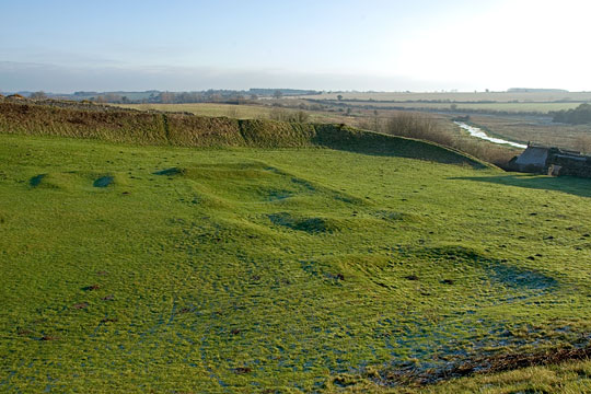
The inner bailey and motte were subject to major archaeological excavations in the 1970s and 1980s, but questions remain, in particular about the function of the stone building within the inner bailey. The outer bailey is known to contain the footings of major medieval buildings and there must have been others. All await investigation.

Recent Research
Aspects of Castle Acre Castle have been well studied, including the form and development of the inner bailey (1970s and 1980s),[1] and the castle’s 12th-century landscape context (2000 onwards).[2] Much has been written about the Warenne family, and the Warenne Chronicle was published in 2013.[3]
Questions for Future Research
Neither castle nor town, however, has been the subject of comprehensive archaeological or historical study. The many questions which remain to be considered include:
- The stone building in the inner bailey: What was its original purpose? Was it a whole house, or always intended to function in conjunction with other buildings in the outer bailey?
- Domestic and secular buildings in the outer bailey: What was the form, date and purpose of the just-visible structures? What other buildings occupied the bailey and how did they change over time? Does evidence survive for pre-Conquest occupation, including the residence of Toki (the landowner in 1066), as suggested in the 1980s?[4] Where was the well? A programme of geophysics could be extremely rewarding.
- Religious buildings in the outer bailey: It has been suggested that the pre-Conquest parish church was probably included in the bailey.[5] But was this the case? Where was it, and the monks’ lodgings that may have stood beside it?
- Date and phasing of the outer bailey ramparts: Does Jonathan Coad and Anthony Streeten’s outline chronology stand up?[6]
- Layout of the town: How were the town’s medieval street plan and property boundaries arranged?
- The Roman road: Is there any archaeological evidence to support Robert Liddiard’s interesting proposal that the Roman road (Peddar’s Way) was diverted from its supposedly original course to the south of the town?[7]
- The 12th-century landscape: Was there indeed a park associated with the castle in the 12th century, and if so where was it?[8]
READ MORE ABOUT CASTLE ACRE CASTLE AND BAILEY GATE
Footnotes
1. J Coad and A Streeten, ‘Excavations at Castle Acre Castle, Norfolk, 1972–77’, Archaeological Journal, 139 (1982), 138–301.
2. R Liddiard, Castles in Context: Power, Symbolism and Landscape, 1066 to 1500 (Oxford, 2005), and ‘The castle landscapes of Anglo-Norman East Anglia’, in Medieval East Anglia, ed C Harper-Bill (Woodbridge, 2005), 46.
3. L Van Houts, The Warenne (Hyde) Chronicle, Oxford Medieval Texts (Oxford, 2013).
4. J Coad, A Streeten and R Warmington, ‘Excavations at Castle Acre Castle, Norfolk, 1975–82: the bridges, lime-kilns and eastern gatehouse’, Archaeological Journal, 144 (1987), 261 and 284.
5. E Impey, Castle Acre Priory and Castle (English Heritage guidebook, London, 2008), 31 (buy the guidebook).
6. Coad and Streeten, op cit.
7. Liddiard, Castles in Context, 134–9.
8. Liddiard, ‘Castle landscapes’, 46.