Research on Harrows Scar Milecastle and Wall
Excavations of the milecastle and clearance of the eastern side of the Wall have taken place over a period of more than a century.

Previous Excavations at Harrows Scar
Following the discovery of the turf Wall in 1895,[1] Francis Haverfield undertook work around the Roman fort at Birdoswald in order to establish the relationship between the different elements in the Wall system.
In this area it was his work in the field between Birdoswald Roman Fort and Harrows Scar Milecastle that established the line of the turf Wall and the Vallum (the earthwork to the south of the Wall) as far as the river Irthing. During this work he also found a Roman stone building constructed over the back-filled Vallum – the earliest evidence for an extramural civil settlement (vicus) at Birdoswald.[2]
Haverfield also carried out the first excavation at the milecastle.[3] It was fully excavated by Ian Richmond in 1953 in preparation for its consolidation by the Ministry of Works.[4]
Clearance
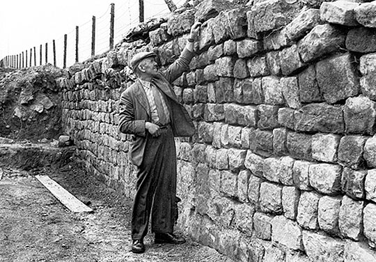
The entire length of Hadrian’s Wall east of Birdoswald was cleared of collapsed debris and shrouding soil by a Ministry of Works team under Charles Anderson from 1956 to 1959. At the same time this section of Wall was also consolidated for display.[5]
During the clearance, a stone-lined burial cist, probably of the immediate post-Roman period, was found adjacent to the Wall.[6]
Geophysical Survey
The fields east of Birdoswald fort and west of Harrows Scar were surveyed in 1997, showing that the whole area was part of the vicus.[7]
Gaps in Current Knowledge
- There is reason to believe that there may have been an original causeway across the Wall ditch at Harrows Scar Milecastle.[8]
- As yet the nature and phasing of Birdoswald’s eastern vicus, apart from geophysical survey and Haverfield’s observation, are wholly unknown.
READ MORE ABOUT HARROWS SCAR MILECASTLE AND WALL
Footnotes
1. F Haverfield, ‘Report of the Cumberland Excavation Committee, 1895’, Transactions of the Cumberland and Westmorland Antiquarian and Archaeological Society, old series, 14 (1897), 185–91 (accessed 21 March 2014).
2. F Haverfield, ‘Report of the Cumberland Excavation Committee, 1898’, Transactions of the Cumberland and Westmorland Antiquarian and Archaeological Society, old series, 15 (1899), 345–64 (accessed 21 March 2014); E Hodgson, ‘Notes on the excavations on the line of the Roman Wall in Cumberland, in 1898’, Transactions of the Cumberland and Westmorland Antiquarian and Archaeological Society, old series, 15 (1899), 365–76 (accessed 21 March 2014).
3. F Haverfield, ‘Report of the Cumberland Excavation Committee, 1897’, Transactions of the Cumberland and Westmorland Antiquarian and Archaeological Society, old series, 15 (1898), 183 (accessed 21 March 2014).
4. IA Richmond, ‘Excavations at Milecastle 49 (Harrows Scar)’, Transactions of the Cumberland and Westmorland Antiquarian and Archaeological Society, new series, 56 (1956), 18–27.
5. A Whitworth, ‘Charles Anderson and the consolidation of Hadrian’s Wall’, in Hadrian’s Wall: Archaeological Research by English Heritage 1976–2000, ed T Wilmott (Swindon, 2009), 61–2.
6. T Wilmott, ‘The late Roman transition at Birdoswald and on Hadrian’s Wall’, in The Late Roman Transition in the North, ed T Wilmott and P Wilson, British Archaeological Reports British Series 299 (Oxford, 2000), 13–24.
7. JA Biggins and DJA Taylor, ‘A survey of the Roman fort and settlement at Birdoswald, Cumbria’, Britannia, 30 (1999), 91–110 (subscription required; accessed 21 March 2014).
8. DJ Breeze, J Collingwood Bruce’s Handbook to the Roman Wall, 14th edn (Newcastle upon Tyne, 2006), 293.