The Roman invasion
Richborough now lies 2 miles inland in the east Kent marshes, but in Roman times it was a small island at the southern end of the strategically important Wantsum sea channel, which divided the Isle of Thanet from Kent. It is widely believed that the Roman Emperor Claudius’s invasion force of 40,000 men landed here in AD 43, in what would have been a massive military operation of great complexity.
The army quickly built a defensive barrier across the island, in the form of two deep, parallel V-shaped ditches, with a rampart on the seaward side, running for at least 650 metres north–south in line with the coastline. This fortification would have defended the invasion beachhead, giving protection to ships, troops and supplies.
In the immediate area of what is now east Kent, Roman troops encountered no resistance, and the army advanced to campaign further inland. Richborough then became a supply base: evidence has been found of large storehouses or granaries that would have provisioned the troops as they made their way inland. The base later developed into a port town, known throughout the Roman world as Rutupiae.
Read more about the invasionThe changing coastline
In the Roman period, the Kent coastline was very different from today. Richborough stood on a small island just offshore, separated from the mainland by a narrow tidal channel. A causeway across it carried the main Roman road, Watling Street, to Canterbury, London and beyond.
The Isle of Thanet was also a true island, separated from the mainland by a much broader waterway, the Wantsum Channel, up to 2 miles wide and 10 miles long.
Richborough island lay close to the confluence of the Wantsum and the open sea. At this point, extensive shingle banks sheltered the Wantsum from the sea, effectively forming a breakwater. This created a sheltered anchorage beside Richborough island, making it an ideal place for the Roman port to develop at a place where the crossing from mainland Europe was short. The Wantsum allowed safe passage of ships to the Thames at Reculver and from there along the estuary to London.
Since Roman times two processes have contributed to massive coastal change. The first was a gradual rise in sea level. On the north coast of Kent, the tidal effects of this rise have eroded the coastline by several hundred metres. Nowhere is this clearer than at Reculver, where half the Roman fort has fallen into the sea and the medieval church towers perch dramatically on a cliff edge.
The second was a slow infilling of the Wantsum, caused partly by the gradual extension of the main shingle bank (Stonar Bank) south from Thanet to the mainland, and the deposition of silt behind it. This created a shallow muddy lagoon, and salt marsh around it, through which navigation became impracticable in the medieval period. Over many centuries, earth dikes and drains were built to exclude water and reclaim land for agriculture. Eventually the Wantsum was reduced to a small stream, Thanet became joined to the mainland, and Richborough was no longer an island.
This landscape change was so extensive that Richborough now lies 2 miles from the sea.
The port town
At the end point of the best sea crossing from Gaul, with a sheltered harbour, Richborough was ideally situated to develop into a major port.
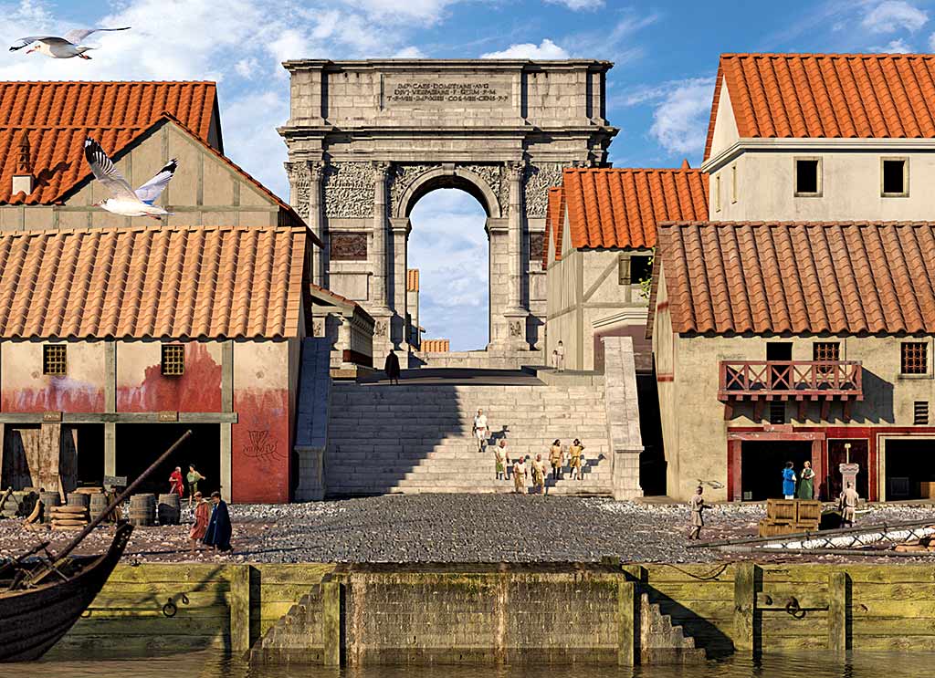
The town included an amphitheatre and one of the biggest monumental arches in the Roman Empire. The arch, probably built sometime between AD 85 and AD 150, was exceptionally large and elaborate. Twenty-five metres tall, it was clad in expensive white Carrara marble imported from Italy, and adorned with sculptures and inscriptions. Such an impressive monument can only have been inspired and resourced by an Emperor. It symbolised Richborough’s status as the gateway to Britain (or accessus Britanniae) – the main port of entry from the Continent.
The heyday of the town was in the 2nd century. An earlier timber mansio – an inn for messengers and officials on government business – was rebuilt in stone, and other buildings including shops lined the streets. These are now partly visible within the area of the later 3rd-century stone-walled fort. Geophysical and aerial surveys, however, have shown that the town extended far beyond the confines of this later fort, covering an area of at least 21 hectares.
The amphitheatre
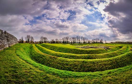
The amphitheatre at Richborough, set on a low but locally prominent hill at the western edge of the town, was probably built in the earlier stages of the town’s development. As at all Roman amphitheatres, Richborough’s arena would have hosted wild beast hunts, probably featuring mainly native species – bulls, wild boars and bears. The execution of criminals and fights between gladiators would also have taken place here.
Today, a broad elliptical mound represents the remains of the amphitheatre’s outer wall, around a large hollow that marks the arena. The first excavation of the site, which took place in 1849, revealed an arena 62 metres long by 50 metres wide, around which up to 5,000 people might have been accommodated.
New excavations in autumn 2021 have shed more light on the amphitheatre’s structure, revealing an arena wall that was plastered and painted, and an outer wall of turf, which helped to support the raked seating bank.
The forts
The town thrived for nearly 200 years, until AD 250, when a drastic change occurred in response to conflicts within the empire and attacks by Saxon and Frankish raiders in the English Channel. Buildings in the centre of the town were demolished and replaced by a small fort. Shortly afterwards this fort was replaced by another, when the monumental arch was dismantled and its materials reused.
The second fort, built in stone sometime in the period AD 275–90, is the most prominent feature on the site today. It formed part of a chain of coastal forts defending the eastern and southern coasts of Britain (and, in Richborough’s case, the Wantsum Channel) from the late 3rd century. They are generally called ‘Saxon Shore forts’.
Excavations outside the amphitheatre found evidence of Roman settlement throughout the 4th century, so we know that the town was only partly militarised. It also seems that Richborough continued to be important as the entrance to Britain. At the very end of the Roman administration of Britain, it may well have been the last site in the province of Britannia to which Roman coins were supplied. This makes it one of the last remaining places of Roman official contact, into the early 5th century.
Read more about the Saxon Shore fortsLater history and rediscovery
The foundations of an Anglo-Saxon church at Richborough probably date to the 10th century, though it may have had a timber predecessor as early as the 7th century.
Richborough’s subsequent history during the medieval period is relatively unexplored. But people were living there into the 15th century, possibly in a tiny settlement trading under the umbrella of the nearby port of Sandwich. Its significance had dwindled, however, because of the silting of the Wantsum Channel and the consequent growth of Sandwich. The small 10th-century chapel remained in use until the late 17th century.
Interest in Richborough was reignited by antiquarian visitors from the 16th century onwards, provoking many tales about the place and theories about the feature that was later discovered to be a monumental arch. There were excavations of the amphitheatre and arch in the 19th century. In the 1920s and 1930s, extensive archaeological excavations revealed how long the town had lasted and its importance to the story of Roman Britain, as well as uncovering an extraordinary range of objects. The whole area within the walls of the Saxon Shore fort was excavated at this time and laid out for public display much as it appears today.
More recently, aerial photography and geophysical surveys have revealed the extent of the Roman town. Much about this complex site, however, remains to be discovered.
Related content
-
VISIT RICHBOROUGH ROMAN FORT AND AMPHITHEATRE
Richborough is perhaps the most symbolically important of all Roman sites in Britain, witnessing both the beginning and end of Roman rule.
-
THE ROMAN INVASION OF BRITAIN
In AD 43 Emperor Claudius launched an invasion of Britain. Why did the Romans invade, where did they land, and how did their campaign progress?
-

History of Reculver Towers and Roman Fort
Today the remains of Reculver’s medieval church dominate the coastline, but this was also the site of another Saxon Shore fort in Roman times.
-

THE RICHBOROUGH AMPHITHEATRE: DISCOVERY AND EXCAVATION
Excavations of Richborough’s Roman amphitheatre in 2021 produced some revolutionary results. Find out what the archaeologists discovered.
-

GATEWAY TO BRITANNIA: RICHBOROUGH’S ARCH
The story of Richborough’s monumental arch reveals the great importance of Richborough to the Romans as the gateway to Britannia.
-
Explore Roman Britain
Learn more about Roman daily life, politics, religion, art and commerce from our articles about Roman Britain.
-

Download a plan
Download this PDF plan of Richborough Roman Fort to see how its buildings developed over time.
-
MORE HISTORIES
Delve into our history pages to discover more about our sites, how they have changed over time, and who made them what they are today.

