History of Heddon-on-the-Wall
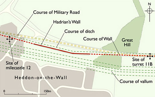
Most of Hadrian’s Wall from the outskirts of Newcastle as far as turret 33b further west lies under the Military Road, built in the aftermath of the Jacobite uprising of 1745. At Heddon, though, for a short distance the road turns slightly north, and stretches of Hadrian’s Wall 220 metres long and of the Wall-ditch to its north are visible. This fragment of the Wall is the best preserved of all those so far excavated which were built to broad gauge – the original specification for the Wall when building began about AD 122. A late medieval or post-medieval corn-drying kiln cut into the core of the Wall here is an example of the many ways in which its ruins were exploited by people living along its line.

The Broad Wall
This length of Hadrian’s Wall was built to broad gauge, with a notional width of 10 Roman feet (2.96 metres). This was the original specification for the whole Wall when building began in about AD 122. Soon afterwards, however, this was reduced to the narrow gauge of 8 Roman feet (2.37 metres), again notional, presumably to increase the speed of building.
In all likelihood, the Wall at Heddon was completed late in AD 122 or at the beginning of the building season in AD 123 (though doubt has recently been cast on this dating – see Research on Heddon-on-the-Wall).
Defences
North of the Wall here, and separated from it by a level area or berm 6 metres wide, is a section of the ditch which ran the length of Hadrian’s Wall. The ditch can be seen more clearly just to the east, in the wood north of the Military Road (the B6528).
Recent excavations in Tyneside have shown that on the berm there are three lines of closely spaced pits; each pit probably held the ends of two forked branches to form an impenetrable entanglement – the Roman equivalent of barbed wire.[1] This system of pits was also seen in trenches dug for new water mains just beyond the summit of Great Hill to the east of the Wall at Heddon. It almost certainly continued in front of the Wall here.[2]
Later Roman History
Nothing is known for certain of the later Roman history of the Wall at Heddon. Just to the east, however, at the summit of Great Hill, is evidence that the Wall may have been repaired. The Wall’s continuation here was examined before its removal in 1926, when the modern road was placed in a shallow cutting. Between the Wall-faces there was a ‘concrete’ core which had to be removed by blasting.[3]
This is the only definitive instance of this type of core to have been recorded in the original construction of the Wall, or what has been so regarded. Normally, the core is of clay and rubble, or predominantly of rubble mixed with a little earth. At Heddon, there are contradictory descriptions of the core, stating that it was either mortared or of clay.[4] These might be explained by the presence of both types of core in the substantial length which was exposed.
The rarity elsewhere of mortar being used in the core of the original Wall, and indeed the sparing use of it even in the Wall-faces (where sometimes clay was used for pointing instead), raises the possibility that the ‘concrete’ core represents a much later repair, made at a period when mortar was being used extensively in the renovation of the Wall.
Post-Roman History
After the building of the Military Road, the Wall at Heddon remained as a mound capped by a hedge, though with some of its north face visible, until some date between 1867 and 1879, when the corn-drying kiln at the west end and a short length of the adjacent Wall were exposed.
In 1924 the remains were given to the Society of Antiquaries of Newcastle upon Tyne by the philanthropist Sir James Knott, and in 1927 a few trenches were dug to examine the north and south faces of the Wall. It was cleared and consolidated for permanent display in 1936–8 and passed into the care of the state.
READ MORE ABOUT HEDDON-ON-THE-WALL
About the Author
Paul Bidwell is an independent archaeology and heritage consultant. He has published extensively on Hadrian’s Wall, Roman south-west England, Roman architecture and Roman ceramics.
Footnotes
1. P Bidwell, ‘The systems of obstacles on Hadrian’s Wall: their extent, date and purpose’, Arbeia Journal, 8 (2005), 53–75.
2. T Frain, J McKelvey and P Bidwell, ‘Excavations and watching briefs along the berm of Hadrian’s Wall at Throckley, Newcastle upon Tyne, in 2001–2002’, Arbeia Journal, 8 (2005), 29–52.
3. P Brewis, ‘Notes on the Roman Wall at Denton Bank, Great Hill and Heddon-on-the-Wall – Northumberland’, Archaeologia Aeliana, 4th series, 4 (1927), 109–21 (accessed 21 February 2013).
4. E Birley, ‘Hadrian’s Wall: some structural problems’, Archaeologia Aeliana, 4th series, 38 (1960), 39–60.
