History of Garrison Walls, St Mary’s
With a history that spans 350 years, the defences of the Garrison on St Mary’s, Isles of Scilly, form one of the most remarkable and impressive coastal defence systems in England.

Elizabethan Period
The Isles of Scilly were recognised as a possible base for attacks on shipping from the 1550s onwards, but during much of the reign of Queen Elizabeth I (1558–1603) the islands’ defences were neglected.
Nothing was done to strengthen them before the attack of the Armada in 1588, but the probability that King Philip of Spain would send a second armada made it vital to take action.
For some years the islands had been leased to the Cornish Godolphin family, and it was the head of this family and governor of the islands, Sir Francis Godolphin, who was given the task of constructing new fortifications.
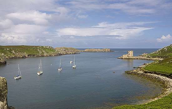
The site chosen was The Hugh, a prominent headland jutting out on the west side of St Mary’s. The nucleus of the scheme was Star Castle, built in 1593–4 (now a hotel).
To protect it on the landward side, a length of curtain wall was built across the neck of the headland from coast to coast, with four bastions and a fortified entrance. Godolphin took his responsibilities seriously, and in 1595 expressed his concerns that ‘the gathering of these Spaniards seemeth as a cloud that is like to fall’.
English Civil War
The Spanish threat never materialised. But during the English Civil War the Royalists initially held the Isles of Scilly, and in March 1646 the future Charles II stayed on the island for a few weeks before slipping away to the safety of Jersey.
The Royalists surrendered to Parliament the following September, but after a revolt two years later the Garrison again became a Royalist stronghold, and a base for up to 800 men.
Finally, in 1651, the Parliamentarian Admiral Blake, after capturing Tresco, turned the full force of his guns on The Hugh, forcing a Royalist surrender.
Later Centuries
Invasion by France or Spain remained a possibility during the 17th and early 18th centuries. The Elizabethan curtain wall was gradually extended until it surrounded almost the whole of the headland, with bastions covering every possible angle of approach from sea or land.
The Godolphins remained in charge, with most of the major work being carried out between 1715 and 1742 under the supervision of Abraham Tovey, the resident master gunner.
Many of the surviving buildings on The Hugh date from this time, including workshops, stores and houses as well as defensive structures. It was during this period that the concentration of defences on The Hugh led to it becoming known as the Garrison.
Further strengthening of the headland took place between 1898 and 1901, when the massive Woolpack and Steval batteries were added, with the Greystones Barracks between them. Between 1902 and 1906 these were supplemented by Steval Point Battery and, on the north-west coast of St Mary’s, Bant’s Carn Battery, built for quick-firing guns.
World Wars
The Garrison was used again in the First World War, when it was re-armed and accommodated almost 1,000 servicemen.
In the Second World War the Isles of Scilly were at the forefront of the Battle of the Atlantic. Large numbers of servicemen were again stationed here and the Garrison was an important signal station, with pillboxes cleverly constructed within the 18th-century batteries.
Description
The fortifications of the Garrison are very well preserved, and visitors today can walk much of the length of the Garrison Walls (the north-eastern stretch between Garrison Gate and Store House Battery is not open to the public).
The Tudor curtain wall across the neck of The Hugh, dating to about 1600, is built from large granite blocks. A deep rock-cut ditch is visible in places along the town side, although this is partly silted up.
This part of the wall and its batteries were partly rebuilt in the 18th century, when Abraham Tovey extended the defensive scheme around most of the headland. Note the contrast between the well-cut ashlar blocks of the 18th-century walls and the rougher masonry of the Tudor section.
At Garrison Gate, the original arched gateway survives, as remodelled by Tovey with a bellcote and parapet above, together with barracks on either side and a guardhouse. The initials GR, FG and AT, and the date 1742, commemorate the work – the initials are those of King George, Francis Godolphin and Tovey himself.
Just beyond the gate is a sunken powder magazine, later called the Rocket House. Tovey surrounded this 17th-century structure with a massive blast-protection wall; a wise precaution at a time when accidents with explosives were not uncommon. A small prison cell adjoins the outer side of the blast-wall’s entrance. The magazine now houses an exhibition about the Garrison’s history.
Beyond the magazine and Star Castle, the defences of the Garrison, together with barracks, stores and workshops, are spread out across the headland. The 18th-century walls extend all around the headland apart from its north-west coast; the stone-faced earthen bank and inner ditch, or breastwork, running along the clifftop is a remarkable survival from the Civil War.
Large 18th-century bastions along the curtain wall were designed to cover the main sea approaches, while the higher slopes of the headland are dominated by the early 20th-century batteries that were built to counter attacks from enemy cruisers and torpedo boats.
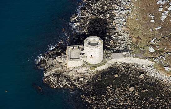
Of the latter, only Woolpack Battery is now accessible. The tower near the centre of the headland was a 16th-century windmill, rebuilt as a gun tower and converted into a signal station in the 1870s: it is now in private use. The cannon on display at several of the batteries date from the 18th and early 19th centuries.
Further Reading
The Garrison, St Mary’s Isles of Scilly: A Walk Around the Walls (Bristol: English Heritage)
Bowley, RL, Scilly at War (St Mary’s, 2001)
Morley, B, Henry VIII and the Development of Coastal Defence (London, 1976)
Tolhurst, M, The English Civil War (London, 1992)
Wilkinson-Latham, RJ, Discovering Artillery (Princes Risborough, 1987)