Description of Hadrian’s Wall
As first planned, the Wall consisted of a wall of stone or turf fronted by a wide and deep ditch. The original plan was for a guarded gate (milecastle) every mile, with two observation towers (turrets) in between. Before work was completed, 14 new forts were added, together with an earthwork known as the Vallum to the south.

WHAT SURVIVES
The surviving remains of Hadrian’s Wall consist not just of the Wall itself, but a variety of associated elements:
- forts and civil settlements
- milecastles and turrets
- towers
- bridges
- temples
- the ditch with an upcast mound to the north
- the forts, milefortlets and towers of the Cumbrian coast
- the Vallum earthwork with its causeways and crossings
- the road known as the Military Way along the Wall and the Stanegate to the south
- earlier and contemporary forts along the Stanegate.
All these sit within a wide contemporary Roman military landscape containing at least five forts to the north and many as far south as the legionary bases at York and Chester, and indeed beyond.
WHERE TO SEE IT
Follow the links for details of English Heritage sites. Sites are listed from west to east.
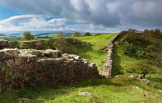
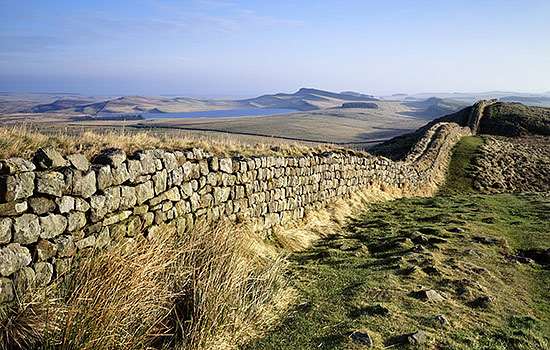
The Wall Itself
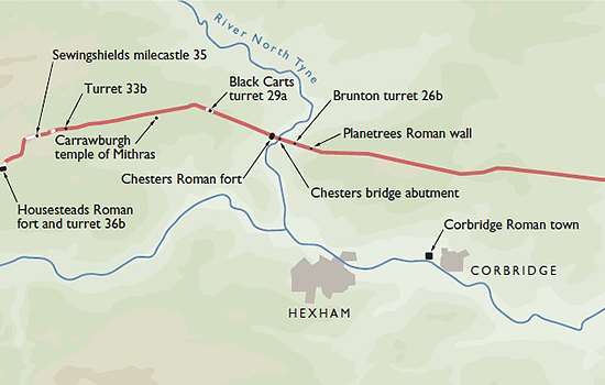
The Wall itself survives mainly in the central sector from Black Carts turret (T29a) to Banks East turret (T52a), including the stretches maintained by English Heritage at:
- Hare Hill
- Birdoswald
- Harrows Scar
- Willowford
- Walltown Crags
- Cawfields
- Winshields
- Sewingshields
- Housesteads
Further east there are stretches of Wall at Heddon and Planetrees.
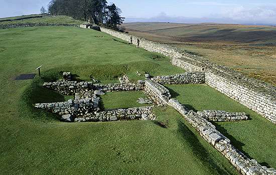
Forts
- Maryport (earthworks only)
- Birdoswald
- Carvoran
- Great Chesters
- Vindolanda
- Housesteads
- Carrawburgh (earthworks only)
- Chesters
- Newcastle
- Wallsend
- South Shields
Milecastles
Part or all of nine milecastles, and one milefortlet on the Cumbrian coast, are visible (others survive as earthworks). They are numbered from east to west.
- milefortlet 20 (Swarthy Hill)
- Harrows Scar (49)
- Poltross Burn (48)
- Cawfields (42)
- Castle Nick (39)
- Housesteads (37)
- Sewingshields (35)
- Shield-on-the-Wall (33)
- Tower Tye (29)
- Westgate Road (4)
Turrets
Sixteen turrets are visible (also numbered from east to west):
- Banks East (52a)
- Piper Sike and Leahill (51a and 51b)
- Birdoswald West (49b)
- Willowford East and West (48a and 48b)
- Walltown (45a)
- Mucklebank (44b)
- Caw Gap (41a)
- Housesteads (36b)
- Sewingshields Crag (35a)
- Grindon West (34a)
- Coesike (33b)
- Black Carts (29a)
- Brunton (26b)
- Denton (7b)
Towers
- Pike Hill
- Peel Gap
Bridges
- Stones from the Carlisle bridge in Bitts Park, Carlisle
- Willowford
- Chesters
Ditch
The ditch is intermittently visible from Wallhouses (MC18) to Garthside (T54a).
Vallum
- Intermittently visible from Wallhouses (MC18) to Garthside (T54a)
- Vallum crossing at Benwell
Roads
The Military Way and the Stanegate are visible at some places in the central sector.
Civil Settlements
- Vindolanda
- Housesteads