Significance of Wharram Percy Deserted Medieval Village
Wharram Percy is among the biggest and best-preserved of the thousands of deserted medieval villages in Britain, and, for this type of site, it has an unusually rich material culture. Its real significance, however, stems from the innovative and extensive research focused on the site between 1948 and 2012, under the leadership of the economic historian Maurice Beresford and a succession of renowned archaeologists.

Importance as a Deserted Medieval Village
About 3,000 deserted medieval villages survive in Britain, with countless more preserved to some degree as archaeological remains buried beneath villages that are still inhabited.[1] Many of Wharram’s components – its church, manors, green, planned rows of peasant houses, and open field system – can be seen as normal characteristics of this type of site.
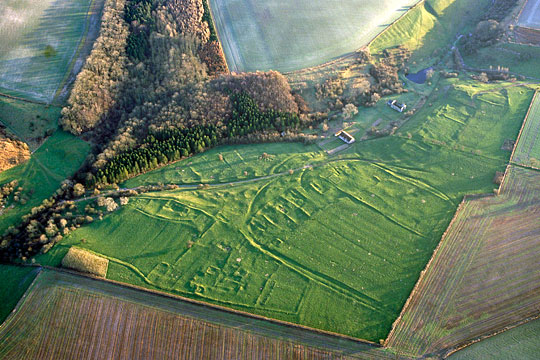
The use of stone foundations at Wharram, however, coupled with the long history of post-medieval grazing, is unusual. Few such settlements – certainly none where building stone was unavailable or where later ploughing and/or development have taken place – can be so readily understood or appreciated through their visible earthwork remains.
Above all, it is the ‘group value’ of the whole village, and its context within a multi-period landscape, that make Wharram Percy’s physical remains significant. There are remains of different types and dates of building, and the plan of the whole village is known, so that each component can be understood in the context of others. Some individual elements, however, can perhaps be singled out as being particularly important:
- The late Iron Age and Romano-British farming settlements (so-called ‘ladder settlements’), because most other examples of these have been damaged by modern ploughing
- The Middle Saxon (7th-century) settlement, because this type (the so-called ‘Butterwick type’) has only recently been recognised as a regional phenomenon and because most other examples have been damaged by modern ploughing
- St Martin’s Church (designated Grade I), perhaps less because of its rarity or condition than because of the intensity of research applied to it
- The excavated human bone assemblage, which represents an invaluable resource for understanding medieval populations
- The relatively large assemblage (for this type of site) of domestic finds,[2] which reveal the lifestyles of the occupants with unusual clarity.
The Contribution of Research
The innate significance of the physical remains has been greatly amplified by the innovative, intensive and extensive research that took place here between 1948 and 2012, leading to an exceptional archive and a 13-volume series of reports.[3]
Designed from the outset as a test-bed for new techniques and approaches, the Wharram Research Project involved Britain’s first open-area excavations,[4] and its first total excavation of a church. It was a step towards multidisciplinary approaches, which seek to set a site in its social, economic and other contexts.
Even as early as 1851 Wharram Percy was one of only a handful of non-elite medieval sites to be mapped by the Ordnance Survey.[5] Later research here involved a number of significant archaeologists and historians, including JK St Joseph (1912–94), Maurice Beresford (1920–2005), John Hurst (1927–2003), Philip Rahtz (1921– 2011) and Stuart Wrathmell (b.1947).
The research project led directly to the foundation in 1952 of the Deserted Medieval Village Research Group, eventually renamed the Medieval Settlement Research Group, and played a major role in legitimising the study of peasant life.[6]
Through regular publicity Wharram Percy has come to epitomise deserted villages and the medieval countryside in general in the public imagination. This arguably makes it just as significant culturally as physically.
READ MORE ABOUT WHARRAM PERCY DESERTED MEDIEVAL VILLAGE
Footnotes
1. M Beresford, The Lost Villages of England (London, 1954), remains one of the best introductions to the subject.
2. E Marlow-Mann and S Wrathmell, ‘The excavations, 1950–1990’, in Wharram XIII: A History of Wharram and its Neighbours, ed S Wrathmell (York, 2012), 3.
3. Wharram XIII presents reappraisals of much of the earlier work and offers a gateway to the previous reports.
4. E Bentz, ‘The Danish connection: Axel Steensberg and Wharram Percy’, in Wharram XIII, 10–23.
5. Ordnance Survey, first edition 6-inch map, 1854, sheet 143.
6. J Hurst, ‘History of the excavation’, in Wharram I: Domestic Settlement 1: Areas 10 and 6, ed D Andrews and G Milne (London, 1979), 1.
